Steel City Traction 3
The North Side
Narration Script
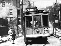
Most trolley enthusiasts consider Route 21 - Fineview the most spectacular line on Pittsburgh's North Side, if not the entire Pittsburgh Railways trolley system. So without further ado, we'll go directly for a ride.
During its last months, Fineview left downtown on the 7th Street bridge, used Ohio to regain its traditional route up Federal Street, attacked the 12% grade up Henderson Street, and wound through Fineview over a dozen streets - some in name only - to reach the end of the line at Charles and Perrysville, returning via Perrysville and Federal, jogging over to the 9th Street bridge to avoid the construction at the Allegheny Center redevelopment project.
Ahead is the 6th Street bridge, Route 21 -Fineview's traditional exit strategy from downtown. A one block jog along Fort Duquesne Boulevard takes us to the nearly identical 7th Street Bridge, which becomes Sandusky Street on the North Side.
Almost all the shots in this sequence were photographed by Jeff Mora.
The junction at Sandusky and Ohio takes us back to Federal Street, and we skip directly up to Henderson where the line turns off Federal and begins climbing.
Turning from Henderson onto Carrie, the steepest grade on the line, about 121/2%, and one of the steepest on the entire Pittsburgh trolley system.
Turning from Carrie onto Warren, and almost immediately onto Catoma.
Catoma onto Lanark, one of those "streets," unique to Pittsburgh, that consisted only of the paving that the trolley company was required to maintain around its tracks.
The summit of the line, 455 feet above the downtown loop.
That jog carries the line from Lanark onto Biggs...
While Glenrose is a right-angle turn from Biggs.
The short stretch of private right-of-way takes us onto Hazelton.
We take temporary leave of Hazelton to turn onto Bark.
Now we're on Wurzell, about to turn left into Brule.
Brule into Magnet.
The turn takes us ever so briefly back onto Hazelton, and then immediately into Charles, and the layover point.
The return trip is over Perrysville Avenue, trackage shared with Route 8 - Perrysville, the most heavily-used North Side route, second-heaviest in the entire system.
The house on the corner straight ahead used to be the lower station of the Nunnery Hill Incline - we are back to where the route branched off Federal onto Henderson. More about the incline later.
And straight ahead is the Allegheny Center redevelopment project that closed the tracks on Federal Street, forcing us to jog over Ohio, Sandusky, and Lacock to reach the 9th Street Bridge.
Street railways came to Pittsburgh in 1859, in the form of horsecars, first out Penn Avenue to 34th Street. Shortly thereafter the Pittsburgh, Allegheny & Manchester opened routes in Allegheny City, as the North Side was then called, and they and their competitors soon blanketed the lowlands along the rivers, using the 6th, 7th, 9th and 16th Street bridges to reach downtown.
To bring reliable transportation to the higher areas, another form of motive power was needed. The Observatory Hill Passenger Railway, a pioneering electric line, opened in 1887, from Ohio Street, up Federal and Perrysville four miles to Butcher's Run Plank Road, now East Street. Power was transmitted to the cars via underground conduit and a slot between the rails downtown, and using overhead wires up on the higher ground.
By 1902, when this panoramic map was made, electricity was powering most of the streetcars in Pittsburgh. The 6th Street Bridge, nearest of these across the Allegheny River, was the setting the same year this map was published of a motion picture called Panoramic View from Pittsburgh to Allegheny. Allegheny was incorporated as a borough in 1828 and a city in 1840. It wasn't annexed by Pittsburgh until 1907, five years after this film was made. The foot traffic was even heavier than the trolley traffic.
Incidently, this 6th Street Bridge was dismantled and floated downstream to join Neville Island to Coraopolis in 1927, where it remained until 1994. It carried streetcars of Route 23 - Sewickley until 1952. The three nearly identical bridges that replaced this, the 7th and the 9th Street bridges are known as the Three Sisters.
The new baseball stadium would be about here.
The beginning of this longish shot is fairly common in documentaries about the turn of the last century in America, but many trolley enthusiasts wonder what the rest of the shot reveals; this is the whole thing.
Let's take a look at the few shots we have of a North Side trolley route that was one of the earliest to end rail service, Route 12 - Evergreen, closed in 1953. We approach the end of the line, but wait! It looks like the tracks used to continue - where did they go?
They were the tracks of the Pittsburgh, Harmony, Butler, and Newcastle Railway - let's call it the Harmony Route, as did most of the people who rode it to and from the communities on its dash sign. The Harmony Route, in blue, opened in 1908, just one year after the Butler Short Line, in red. Both connected Butler to Pittsburgh, and eventually came under common ownership. They were interurban electric railroads, distinguished from ordinary city trolleys by their large heavy cars, more like steam railroad coaches, but distinguished from steam railroads by their electric motive power, which allowed more frequently scheduled service on relatively lightly traveled lines. The Short Line originally used high voltage alternating current on its own tracks, collected by the pantograph in the center of its roof, and ordinary 600 volt current collected by trolley when running over the tracks of Pittsburgh Railways into downtown - this is 6th and Penn.
The Harmony Route terminated nearby at 6th and Liberty. This postcard view was hand-colored, and as often happened, they got it wrong - the car should have been maroon, as they are in these other views. Both lines were substantially built, with heavy steel bridges, and well-ballasted roadbed. Limiteds made schedule speeds of over 25 miles per hour including stops, pretty good performance for 1908 given the hilly terrain. The Harmony Route even attracted excursion business with a special party car outfitted for silent movie projection. Three-way meets were scheduled at the triangular junction at Evans City so passengers could easily transfer between cars to or from Pittsburgh, Butler, and New Castle.
The Short Line went into receivership in 1917, two years after this busy-looking photo was taken, and was eventually bought by the holding company which owned the stronger Harmony Route. Even the merged system began losing money around 1925, and in 1931 it got permission to abandon service.
So, now, back to Route 12 - Evergreen, changing ends and returning downtown. This spot is now a busy expressway interchange.
Routes 1 through 5, on the north bank of the Allegheny and upstream from the center of the North Side, were abandoned in 1952 and 1957, so coverage is a little spotty. Routes 1 and 5 used the 16th Street Bridge, and we will see both PCCs and low floor cars on the steep Route 5 - Spring Hill, PCCs on relatively level Route 1 - Spring Garden, and both car types on Route 4 - Troy Hill. (That yellow line at the right marks the location of the Troy Hill incline, closed in 1898.) There are some shots at the end of Route 3 - Millvale, and a shot of a car on Route 2 or 3 running along East Ohio Street, before we return over the 16th Street Bridge.
This is an outbound car on Chestnut Street. The line becomes single-track just before the junction where Route 1 - Spring Garden branches off.
The steep hill up Itin Street. Most of the shots in this sequence were shot by Charlie Dengler and Russ Jackson.
The Rhine Street loop at the end of Route 5 - Spring Hill. We'll jump back in time to show the completion of construction of the loop to accomodate PCCs. Prior to that the route was served by double-ended low-floor cars.
Some people called these cars "yellow cars" - here's why. The original orange paint weathered quickly to yellow in Pittsburgh's industrial atmosphere.
At the foot of Itin Street, a derail was positioned to prevent a runaway car from crashing down busy Chestnut Street.
Our inbound Route 5 car passes an outbound Route 1 - Spring Garden turning at the single-track junction at Chestnut and Spring Garden Streets - Route 1 becomes double-track again after the junction. Route 1's loop was at Spring Garden and Wickline Streets.
The end of Route 4 - Troy Hill at Lowrie and Roessler Streets.
The single track in Lowrie Street became double for the rest of the route inbound just before Gardner.
Approaching the end of Route 3 - Millvale.
A Route 2 - Etna car inbound on East Ohio Street.
Rail service on Route 18 - Woods Run didn't end until 1961, but coverage on this route is spotty as well.
These World War II era shots are at Western and Allegheny.
We skip to the end of the line in more recent times, shot by Carleton McKinney..
Crossing Brighton Road and the tracks of Route 6, which we will see later.
Turning from Columbus onto Sedgwick, right next to the Pennsylvania mainline, the tracks are squeezed close together in a perfect example of a non-clearance curve.
The bridge girders support the street as it crosses the Pennsy mainline.
Since several North Side routes terminated on the North Side without crossing the Allegheny into downtown, Route 22 - Crosstown provided that link, as well as providing local travel between downtown Pittsburgh and what used to be downtown Allegheny City.
The layover point for the Crosstown line was on North Avenue at Sandusky, alongside Pittsburgh City's North Park.
6th Street Bridge carried it into downtown,
The block of Stanwix between Penn and Fort Duquesne Boulevard was shared with all the West End routes, but traveling in opposite directions.
Fort Duquesne Boulevard back to 6th completes the loop.
Route 22 - Crosstown's cars often carried special paint jobs, because its short route through the thick of downtown and the North Side gave just a few cars maximum visibility. Although the custom started earlier, it really took off during World War Two, supporting the war effort with paint jobs like these. After the war, the custom continued with both civic and commercial advertising, or the famous "Mod Desire" which celebrated only itself.
During World War Two, Route 21 - Fineview still looped on the North Side. Where it turned from Federal onto Henderson, it briefly ran parallel to the former path of the Nunnery Hill incline, in yellow, which was built during 1887 and 1888 by Samuel Diescher who designed most of the other inclines in Pittsburgh, and was simultaneously building, as construction contractor, the pioneering Observatory Hill electric line. That's Mr. Diescher standing on the tracks. The incline closed in 1899. In 1908 the Fineview electric trolley line effectively replaced and extended it. Those two shorter inclines to the left, the Clifton and the Ridgewood, were also Diescher projects.
Fineview was the last North side route to use low floor cars. These films, shot during World War Two by Arthur Ellis, show one mingling with new PCCs on Federal Street. Two cars were required to maintain a 20-minute service. When PCCs were introduced to Fineview, their superior performance enabled 2 cars to maintain a 20-minute service over a route extended to loop downtown.
Turning to loop through Lacock, Anderson, and Robinson.
Heading up Federal.
The turn from Federal onto Henderson.
Approaching the curve from Henderson onto Carrie. Right after the turn, note the derail in the lefthand rail, designed to stop a runaway car before it could plunge several hundred feet down into the heart of the North Side.
This is the summit.
The track alongside Glenrose Street was relatively straight and level for the Fineview line.
Turning from Hazelton onto Bark.
Down in the valley you can just see a PCC heading inbound on East Street...
While up on the hillside the Fineview car turns from Brule onto Magnet.
Magnet into Hazelton, and Hazelton onto Charles and to the layover point.
Until 1951, this intersection was also the terminus of Route 9 - Charles Street Transfer, an extension of Route 7 - Charles Street, which connected with both the Ridgewood and Clifton inclines. We have a few shots of Routes 7 and 9.
Turning from West North Avenue into Monterrey.
On Charles approaching Strauss, about where the lower station of the Clifton incline would have been until 1905. Charles Street carhouse, closed in 1925, was just a few blocks farther along, where the lower end of Route 9 terminated. This is the upper end at Charles and Federal.
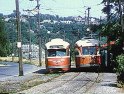
Inbound Route 21 - Fineview shared Perrysville Avenue and Federal Street tracks with Route 8 - Perrysville, which was heavily patronized, but seldom photographed.
The Fineview car, heading inbound from its layover point, turning onto Perrysville from Charles.
On Federal Street, passing an outbound PCC car on Route 8 - Perrysville.
This is a cheat - it's actually higher up, on Perrysville, than that last shot, but we wanted to end this sequence in a blaze of color.
Routes 10 - West View and 15 - Bellevue were operated as a loop, 15 clockwise and 10 counterclockwise. Route 10 climbed up the seldom photographed East Street valley and joined Perrysville Avenue just behind this inbound Perrysville car, continuing a few blocks on Perrysville before heading off on private right-of-way.
We'll start our film journey outbound on Route 10 just before the private right-of-way, and continue past West View amusement park to the layover point, where the car simply changed its destination sign to Route 15 - Bellvue, and then continued into town.
Upper Perrysville Avenue.
The beginning of private right-of-way was at the border of the City of Pittsburgh and Ross Township.
This is actually a Fineview car in a big hurry to pull into Keating carhouse, following the same route as an outbound West View car.
Keating carhouse, built in 1921, served all of the North Side trolley routes starting in 1959, when the last trolleys were moved from Manchester carhouse, making it an all-bus facility. Keating closed as a rail facility in 1965, and the remaining North Side cars on Routes 6/14 and 21 were transferred to South Hills Car House.
That's West View Cemetery to the left of screen. This spot is now an expressway exit.
Most of the shots in this sequence were photographed by Russ Jackson, with additional shots by Henry Elsner and Bill Vigrass.
The building on the top of the hill is Holy Ghost Academy.
The Martsolf Avenue Bridge. For most of its length, the right-of-way of the West View loop closely parallels Center Avenue.
That's the Ridgewood Avenue Bridge.
The car is traveling on a long fill that was originally a trestle.
Crossing US Highway 19 or Perrysville Road and passing one of two car stops for West View Park. Although in a certain sense West View was a "trolley park," because at the beginning it was reachable primarily by trolley, it was never owned by Pittsburgh Railways. It was the last amusement park in the US served by a trolley line.
The building was Danceland.
The car on the right is stopped at the barely visible shelter of the other West View Park stop, where cars laid over during the season when the park was open.
The Cornell Avenue Bridge carries the tracks over a tributary to Spruce Run. An expressway now runs through this valley.
The center reservation is in Forest Avenue.
That's a Pittsburgh Railways substation on the right.
Turning from Forest into Balph, nearly to Lincoln Avenue and the junction with Routes 13 and 14.
Route 13 - Emsworth and Route 14 - Avalon, a rush-hour and all-night shortworking of 13, shared the tracks into downtown with Route 15 - Bellevue.
Not far past the junction was the Avalon loop, where Route 14 - Avalon cars turned. The car continuing outbound here is about to cross Spruce Run Viaduct on Route 13.
The trestle over Lowries Run and Camp Horne Road was close to the end of the Emsworth line. Most of these shots were taken by Carleton McKinney.
The wooden tower beside the stationary car was to allow the operator to attach or adjust a sleetcutter on the trolley pole.
The operator gets off to signal his departure using the transmitter mounted on the line pole. A telegraph signal sent automatically from the box is received by a Train Recorder in the central dispatching office. Other signals are received by Headway Recorders from contactors on the trolley wire at various points along the route. The dispatchers use this data to insure punctuality of all the cars on the system, communicating by radio with route foremen in roving trucks to correct any irregularities.
We're back at High Bridge Loop where a railfan charter waits for the service car to pass.
Before we make a return trip over the West View loop, a brief pause to look at the Bellevue and Davis Island Incline Plane Company. They did not, as the name suggests, operate an inclined plane, but actually the first regular electric passenger railway service in Pittsburgh in 1887, beating out by a few months both the Observatory Hill line we saw earlier, and the Pittsburgh, Knoxville, and St. Clair on the South Side. It connected what is now Lincoln Avenue in Bellevue with an outdoor elevator descending to the Bellevue station of the Pittsburgh, Ft. Wayne & Chicago Railroad, thus providing transportation between Bellevue and Pittsburgh. The line lasted less than two years.
Our journey back over the West View loop follows our outbound path for much of the way, but after passing Keating carhouse, we'll take Route 8 - Perrysville back to downtown.
An outbound Route 15 - Bellevue car on Forest at Balph.
This is the location of the layover point for most of the year, where this outbound Route 15 car would change signs and become an inbound Route 10.
Keating carhouse.
We have now left Route 10 - West View and follow a Route 8 - Perrysville car.
Henderson Street, where outbound Fineview cars branch off.
Back on Federal Street at Ohio, a part of the route shared with cars of Route 6/13 - Brighton-Emsworth.
Route 6 - Brighton Road was a relatively heavily-patronized and slow route that stopped just short of the City-Bellevue line. Routes 13 and 14 took faster California Avenue, in effect offering a kind of express service to the more distant suburbs. As North Side trolley routes were gradually abandoned in favor of buses, Routes 6 and 13 were combined in September 1965, keeping the heavier traffic inner portion on Brighton Road while continuing to provide a somewhat slower service to Avalon and Emsworth, and using fewer cars. Route 6/13 was cut back to 6/14 - Brighton - Avalon in December 1965 due to deteriorated bridges between Emsworth and Avalon. Route 6/14 Brighton -Avalon and Route 21 - Fineview were the last two North Side trolley routes, both abandoned on the 30th of April, 1966.
Route 6 cars turned off Federal Street at North Avenue.
That's West Park on the right.
Turning away from West Park and North Avenue onto Monterrey.
Now on Brighton Road, approaching the single-track junction with California Avenue. Route 6 cars like this one continued straight, while Routes 13, 14, and 15 turned left, and Route 7 - Charles Street cars turned right. Three of the four arms meeting at this junction return immediately to double track once past the junction. There simply wasn't enough space for a full double-track junction.
Brighton Road passing Highwood Cemetery.
Turning from Wynhurst into the original pre-1965 terminal loop of Route 6.
The signal on the line pole to the left is protecting the single track on Wynhurst. This Route 6/14 car bypasses the loop and enters the junction with California Avenue near the end of service.
The bridge carries California Avenue over Jack's Run.
A Route 14 car turns into Avalon loop.
And returns.
In earlier days, a Route 15 car approaches High Bridge Loop.
A Route 6 operator on layover at the loop uses the transmitter just prior to departure.
Turning from Wynhurst onto Cambronne Street. Note the signal.
Back at the single-track junction, an inbound Brighton Road car gets aced out by an inbound Bellevue.
Back at the single-track junction, an inbound Brighton Road car follows an inbound Bellevue.
Back at North and Federal, an inbound Brighton Road car followed by an inbound Fineview.
We'll take a farewell trip over Fineview. This map shows the route followed for most of the years after World War Two, when PCCs were introduced. Their superior performance enabled 2 cars to maintain a 20-minute service over a route extended to loop downtown.
Most of the shots in this sequence were filmed on the last day of service, the gloomy and rainy 30th of April, 1966.
Russ Jackson and Art Ellis provided most of the film.
Look carefully and you'll see the car climbing Henderson Street, about to disappear behind Allegheny General Hospital.
Fineview was mobbed by railfans on the last day of service.
This was a railfan charter.
The corner of Catoma and Lanark was the location of the upper station of the Nunnery Hill incline - the vacant lot directly behind the trolley.
That's right, Bark Street.
------------------------------------------------
We thought you might be interested in seeing how all this new digital technology you hear so much about actually improves your viewing experience. Right after the credits, we'll give you a demonstration...
Here's a sequence from the program without any manipulation, other than putting the shots in the correct order. The shaky camera and mismatched exposure are the major problems.
First we stabilize the shaky shot.
We equalize the exposure for each shot.
We correct color differences.
8mm footage tends to be grainy, so we'll eliminate most of the grain.
And finally we can bring back some of the sharpness lost in the previous steps.
Here's how it looks with all the corrections.
Here's how it looks with all the corrections, side by side with the original.
Here's a different sequence, after editing, but without any sound.
It's pretty lifeless, isn't it?
First we add the sounds of the trolley cars.
Each squeal is added separately.
Next we add in the sounds of passing automobiles, each one individually.
And finally we add the general ambience of the neighborhood.
Hey, turn down that radio!
[Up]
[Main]
[Order & Contact]
[Sitemap]